


The best coastal walks and hikes in NSW
Tomaree Coastal Walk, Shoal Bay - Credit: Remy Brand | DPE

From gentle seaside walks to multi-day wilderness treks, NSW has many coastal walks that showcase the state's stunning natural landscapes. Wander past golden beaches, dramatic cliffs and lush forests with opportunities to spot whales, dolphins and native wildlife along the way.
Located in the Sapphire Coast’s Beowa National Park (formerly Ben Boyd National Park), the Light to Light Walk is somewhat of a hidden gem, primed for wilderness adventure. Starting at historic Boyds Tower and finishing at the iconic Green Cape Lighthouse, walkers weave through an ever-changing landscape of red clifftops, sheltered coves, eucalypt forest and coastal heathland, spotting wildlife along the way, including seals, seabirds and seasonal migrating whales. While it’s home to plenty of treasures for those making the trip, the walk’s location in far south NSW often lends itself to fewer interruptions to the sights and sounds of this phenomenal coastline.
Experienced walkers can tackle the track carrying their own packs and supplies, and by booking a two-night self-guided camping experience. Transfer services are available to assist with transport to and from the track, as well as guided experiences by Navigate Expeditions, Park Trek Walking Holidays, Sapphire Coast Guiding Co and Life’s an Adventure.
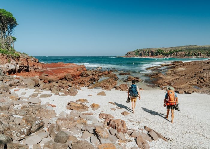
Light To Light Walk, Hegartys Bay - Credit: Remy Brand | DCCEEW
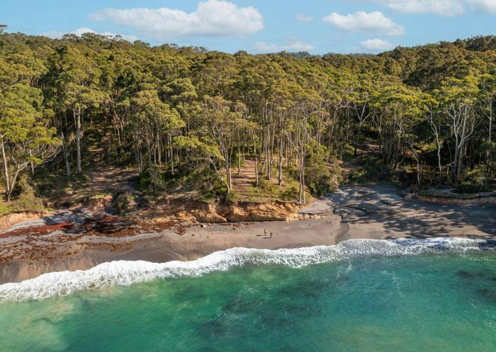
The Murramarang South Coast Walk through the Murramarang National Park passes through coastal villages, secluded beaches and gum forests, starting at Pretty Beach south of Ulladulla and ending at Maloneys Beach just north of Batemans Bay. You can choose to stay overnight in campsites or in cabins along the way, with several multi-day experience packages available through the NSW National Parks and Wildlife Service, including options for transfers and tours. Region X and Women Want Adventure also offers guided experiences.
Keep an eye out for wildlife along the way including lyrebirds, wonga pigeons, eastern grey kangaroos and more. From May to October, the most ideal time to undertake this walk, you may also spot whales as they migrate up and down the coast. Murramarang National Park is also an area of rich Aboriginal cultural heritage. Just north of the start of the walk is Murramarang Aboriginal Area, which is one of the largest and most important Aboriginal sites on the NSW coast.

Murramarang South Coast Walk, Pretty Beach - Credit: Remy Brand/DPE
The Bouddi Coastal Walk hits that strolling sweet spot clocking in at 8.5km one way and takes three to four hours depending on your speed. The southern end of this walk begins at Putty Beach, wrapping up at MacMasters Beach to the north. While the trail is well maintained with some sections of smooth, easy boardwalk there are challenges like the moderate climbs up to clifftops before descending to beaches. If you only have time for one pit stop, make sure it's Maitland Bay and its crystal-clear water. Leave time to take a dip before you carry on with your walk.

Bouddi National Park, Bouddi - Credit: Destination Central Coast
Home to some of the whitest sand in the world, Jervis Bay is a must-visit for the beach-obsessed. Here, the beach characteristics extend into forest at Jervis Bay National Park, where Hare Point Walking Track on the north side of the bay passes through sand forest and dunes. The track is home to native Aussie plants including banksia, tea trees and eucalypt. Despite the name, the 6km track doesn't require you to be speedy to finish in a reasonable time. However, the sandy ground could be more difficult for young children or those with lower fitness levels.
Start at Red Point picnic area, where you can park and return to on completion of the route. If you're looking for a great spot to hang or grab a bite to eat when you're finished, drop into Callala Bay, one of the most popular stop-offs in the area.

Hare Point Track, Jervis Bay - Photo Credit: Michael Van Ewijk/DPIE
The Royal National Park, the second oldest national park in the world, is host to the Coast Walk. Stretching from Bundeena to Otford it’s home to some of the most stunning stretches of sand in NSW, with diverse landscapes peppered the whole way through.
Your best bet is to take your time to really soak it all in; consider splitting this adventure across two days. The popular North Era campground can be your home for the night, with its views over North Era Beach. Just be sure to make a reservation before setting out.
As far as getting to and from the hike, you can rely on public transport and skip the driving. Catch a ferry to Bundeena Wharf, which is a 25-minute walk from the trailhead, followed by a train from Otford train station for your trip home once you're finished.

The Coast Track, Royal National Park - Credit: Andrew Richards | DCCEEW
Spanning a monstrous 65km and requiring four to five days to complete, the Yuraygir Coastal Walk, a Grade 4 track, brings you to the Clarence Valley in northern NSW. Situated between Coffs Harbour and Yamba, you'll be walking the eastern edge of Yuraygir National Park along NSW's longest portion of undeveloped coastline.
Starting from Angourie, just south of Yamba, you’ll encounter a mix of landscapes from grassy heaths and sandy beaches to rocky clifftops and babbling creeks, before taking the trip's final steps in Red Rock a few days later. Pitch a tent or sleep under the stars, or check into a range of accommodation in towns such as Brooms Head, Minnie Water and Wooli. If you've got enough room in your pack, make sure you bring a snorkel. Prefer a guide? Connect Adventures offer guided hike experiences.
The walk can be done both directions, but it’s ideal to go from north to south, with the sun at your back.
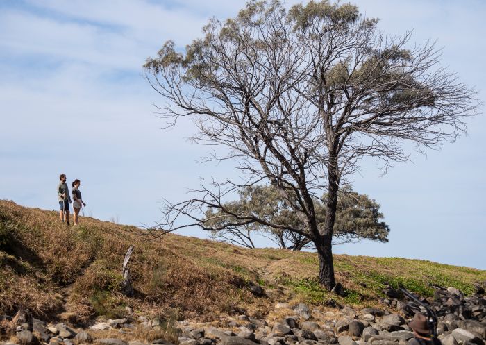
Yuraygir Coastal Walk, Angourie
Beginning at Tomaree Head and weaving through pretty angophora forest, small coastal communities and past secluded beaches to the culturally significant Worimi Conservation Lands, the Tomaree Coastal Walk is a lesson in NSW beach beauty, and an ideal city getaway. The full journey is best experienced as an overnight walk staying at nearby off-park accommodation, however, it can also be completed in three days for a more leisurely pace.
Keen on a shorter, but equally beautiful experience? The Tomaree Head Summit Walk is 2.2km-return, Grade 5 hike overlooking the Jurassic Park-like Shoal, Port Stephens and Fingal Bays, beginning at the end of Shoal Bay Road.

Tomaree Coastal Walk, Port Stephens - Credit: Daniel Parsons/DPE
Coastal drama awaits on the wild and wonderful Kiama Coast Walk, stretching from the Minnamurra River to Gerringong’s Werri Beach. Along the way, see ancient rock formations, windswept headlands and postcard-perfect beaches. If hiking between May and November, keep watch for humpback whales, especially from the Minnamurra Whale Watching Platform or Gerringong Whale Watching Platform. Highlights include Cathedral Rocks, Bombo Headland, Boneyard, Kiama Blowhole, Little Blowhole and Werri Lagoon.
If you’re an early riser you may be able to tackle the entire trail in a day, but many choose to break it up and complete one section at a time: north, mid and south, each approximately 5km to 8km.

Kiama Blowhole Point, Kiama
Popular with surfers, wellness enthusiasts and creative minds, thousands flock to Byron Bay for a taste of a slower-paced, bohemian life. The Cape Byron walking track offers the perfect snapshot of the area’s natural beauty, winding its way through the Walgun Cape Byron State Conservation Area.
You'll be treated to majestic coastal views (and potential wallaby, whale, dolphin and stingray sightings) while dipping in and out of rainforest over this 3.7km loop. The path takes you right up to the Cape Byron Lighthouse, which has stood on watch at the most easterly point of Australia since 1901. The trail isn't too difficult or long, but does feature some moderately steep sections.
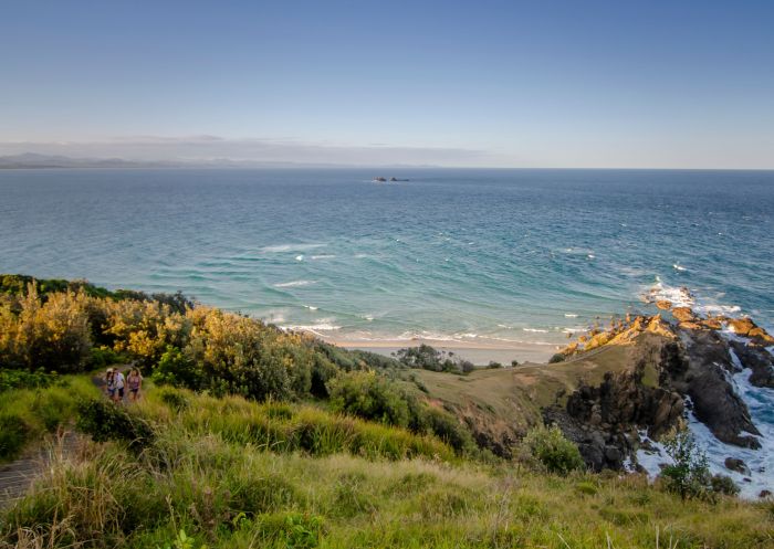
Cape Byron walking track, Cape Byron State Conservation Area - John Spencer | DCCEEW
Newcastle’s beaches are some of the most glorious in the country and, luckily for Novocastrians, many of the beaches are connected on the Bathers Way Walk. In addition to stunning swimming spots along the way, you'll also be treated to wonderful views of the city and its most famous landmarks. In the winter, when it might be a bit too chilly to take a dip, keep your eyes peeled for whales playing out in the sea.
There are many spots to join The Bathers Way Walk, and you can start at either end. In the south, start at Merewether Ocean Baths, where you can head off with a coffee and make use the facilities. You'll pass by Dixon Park, Bar Beach, Newcastle Memorial Walk and Newcastle Beach before ending at the famous Nobbys Lighthouse. If you've still got some juice in your legs, continue out to the end of Nobbys Breakwall for an uninterrupted view of the expansive sea.

Newcastle Memorial Walk, Newcastle
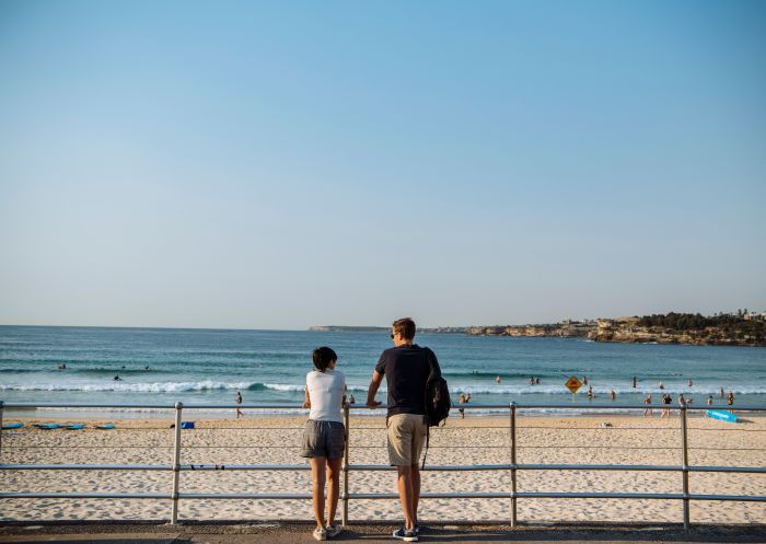
Drawing hundreds of thousands of walkers a year, from local fitness junkies logging their daily steps to out-of-towners eager to see what all the fuss is about, the Bondi to Coogee Coastal Walk is an institution in Sydney's Eastern Suburbs. Hugging the coast, you'll pass some of the city's most storied spots – pause for a game of bowls with a stunning seaside backdrop at Clovelly Bowls Club; pay your respects at Waverley Cemetery, one of the most scenic resting places in the world; and finish up at Coogee with a well-earned drink or bite to eat at the Coogee Pavilion or Coogee Bay Hotel. Extra points if you can plan your visit during the amazing annual Sculpture by the Sea event, which sees artwork deployed around the section of the walk between Bondi and Tamarama.

Coastal walk, Bondi
See the very best of Sydney along the Bondi to Manly Walk. The 80km track is one of only a handful of urban coastal treks in the world and takes in must-see Sydney icons including Mrs Macquarie’s Chair, Sydney Harbour Bridge and Sydney Opera House, as well as historic sites, art galleries, museums, cafes and restaurants and 49 beaches. With signage along the route explaining the Aboriginal connections to the land, it’s an enriching way to immerse yourself in Aboriginal culture and heritage. You can also see Aboriginal carvings between Bondi and Watsons Bay and at Grotto Point, as well as shell middens at Cremorne Point.
Bondi to Manly Walk, Bondi Beach
The track is designed to be tackled in smaller sections, which can be completed over a number of days, either staying overnight at different hotels en route or within easy access to return to Circular Quay and the CBD each evening.
The Northern Beaches’ Spit Bridge to Manly Walk puts your feet on largely unfinished (but very well-maintained) trails. You'll encounter gorgeous coastal views of Middle Harbour, coupled with a mix of bush and brushland, and Aboriginal rock engravings. The route is light on cafes and rest stops, so it’s a good idea to bring water and snacks, but make sure to save room for lunch in Manly. Head to Felons Brewing Co Manly for Mediterranean-leaning pub grub, craft beer and an ideal perch to watch the ferries come in.

Spit to Manly Walk, Manly
Experience the spectacular UNESCO World Heritage-listed Lord Howe Island on the Seven Peaks Walk. The island paradise is regarded as one of Australia’s best walking destinations, from clifftop walks to see its famous twin peaks and unique wildlife to the towering cloud forest and the world’s southernmost coral reef.
The Seven Peaks Walk is part of the Great Walks of Australia’s collection of premium guided walking tours and it operates out of waterfront resort Pinetrees Lodge. You’ll spend six nights at the lodge and five days hiking on the beautiful island, which is surrounded by an iridescent blue marine sanctuary.
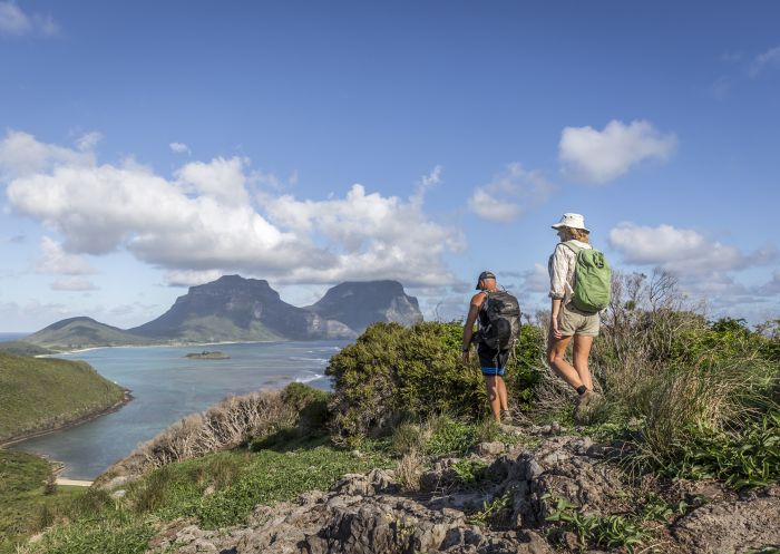
Seven Peaks Walk, Lord Howe Island – Credit: Luke Hanson
The Bundian Way is an ancient 365km pathway from Turemulerrer (Twofold Bay) to the mountain ranges of Targangal (Mount Kosciuszko) that Aboriginal people from Yuin, Ngarigo, Jaitmathang, Bidawal Country have walked for thousands of years.
The Bundian Way Story Trail is a short section of the walk signposted along the way with eight story-telling signboards, highlighting a snapshot of the longer journey and its spectacular coastal scenery.
Beginning at Cocora Beach, the trail journeys through native bushland to a Bunang Ring (ceremonial performance place), up Cocora Point and to Budginbro Lookout. Follow the Story Trail past Sealers Lookout and along the sand at Bungo Beach, going onwards to finish at Quarantine Bay. Bundian Way Cultural Experiences offers guided experiences, if desired.

Bundian Way Story Trail, Eden
Set out on the Munjip Trail in the Eurobodalla from Batehaven near Batemans Bay. Over 15km you’ll be treated to a diverse landscape of bushland, bays, beaches, headlands and rock platforms with artwork, audio guides and stories of the Walbunja people, members of the world's oldest continuing culture, along the way.
Highlights include Wimbie Beach and Mosquito Bay, while the finish point at McKenzies Beach is the ideal place to end a day hike in the outdoors.
Munjip Trail, Batehaven - Credit: Jon Harris | Eurobodalla Shire Council
Tip: Before planning or booking your trip, visit the NSW National Parks website to stay up to date on news, important information, alerts and closures.
VisitNSW.com is the official tourism site for Destination NSW.
© Copyright 2026 Destination NSW. All rights reserved


