


The best multi-day hikes in NSW
Grand Cliff Top Walk at Fletchers Lookout, Blue Mountains - Credit: Daniel Parsons/DPE

Sometimes you just need to explore longer than a one-day outing will allow, to test what you're capable of and expand your horizons. From the sunny coast to the depths of the state's forested landscapes and everything in between, read on to learn more about some of the best multi-day hikes in NSW, with options for both independent trips and guided journeys where you get to ditch your pack and enjoy a homecooked meal at the end of the day.
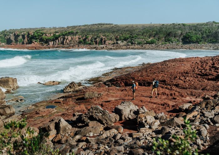
Set a course for the highly underrated Sapphire Coast, specifically, the Light to Light Walk. Located in Beowa National Park (formerly Ben Boyd National Park), this route is a bit of a hidden gem. But it certainly holds plenty of treasures for those willing to make the trip. That means fewer interruptions get in the way of the sights and sounds that come with this phenomenal coastline.
Starting at historic Boyds Tower and finishing at the iconic Green Cape Lighthouse, walkers weave through an ever-changing landscape of red cliff tops, sheltered coves, eucalypt forest and coastal heathland, spotting wildlife along the way, including seasonal migrating whales, seals and seabirds. Experienced walkers can tackle the track carrying their own packs and supplies by booking a two-night self-guided camping experience. Optional transfer services are available from Merimbula and Eden to assist with transport to and from the track.
Go with a guide
Several tour companies take groups on the Sapphire Coast hike, arranging all transfers and accommodation. Park Trek, a tour company that has been running guided hikes since 2000, splits the journey into four days. Ecotourism Australia-certified Sapphire Coast Guiding Co gives you the choice of accommodation or camping, but either way they’ll add a bit of comfort with a homecooked meal based around local produce and a glass of wine each night. Also Ecotourism certified, Navigate Expeditions moves away from the traditional trip format by adding in a kayaking journey (in collaboration with Twofold Aboriginal Corporation), an oyster farm tour and wellness activities. If you prefer to hike without a heavy backpack, Life's An Adventure runs a three-day guided walk where you only need to carry your day bag.
*Light to Light Walk is one of the NSW Great Walks.
Hegartys Bay on the Light To Light Walk - Credit: Remy Brand | DCCEEW
‘Gidjuum Gulganyi’ means ‘Old People’s Track’ and even though this walk launched in 2025, it follows a trail that has been used by the local Indigenous people for thousands of years. This challenging trail winds through the Gondwana rainforest and around the rim of an ancient volcano in the Mount Jerusalem National Park, Whian Whian State Conservation Area and Nightcap National Park. Along the way, marvel at magnificent landscapes, take in the view of Wollumbin (Mount Warning), cross over cascading creeks and finish at the magnificent Minyon Falls.
Three campsites are dotted along the trail, each with 11 raised wooden platforms, toilets and rainwater tanks (though you’ll need to treat the water before drinking). There’s a real focus on building connections with the Indigenous people who have cared for this land for generations and Aboriginal-led experiences will educate and inspire.
Go with a guide
Connect Adventures offers two guided options along the Gidjuum Gulganyi Walk – you can choose to carry your gear the whole length or just walk with a day pack and have everything else transported between the campsites. Vision Walks has a more luxurious pack-free tour, with glamping tents set up when you arrive, hot showers, chef-prepared meals and even a glass of wine or beer. All walks include meals, drinks and snacks; tents, sleeping bags and safety gear; plus transport and national park fees.
*Gidjuum Gulganyi Walk is one of the NSW Great Walks.

Gidjuum Gulganyi Walk - Credit: D Parsons | DCCEEW
This spectacular new four-day walk in Kosciuszko National Park covers 56 kilometres of rugged mountain terrain, linking the alpine villages of Guthega, Perisher Valley and Charlotte Pass. Reach the summit of Mount Kosciuszko – Australia's highest peak at 2228 metres above sea level – and experience the grandeur of the Snowy Mountains in the warmer seasons. Discover majestic snow gum forests, vibrant wildflower meadows, snow-capped mountain ranges and incredible views of high-country plains.
Choose a self-guided adventure and stay in cosy park accommodation, or base yourself in a nearby alpine village to tackle the walk in full or in sections.
Go with a guide
The Adventure Gene, Australian Walking Holidays and the EarthCheck-certified Thredbo Guided Adventures all run guided hikes along the Snowies Alpine Walk, showing you the full magic of the high country. For a little luxury, Ecotourism Australia-certified Life's An Adventure offers pack-free walking, stylish accommodation, and fine food and wine to savour at the end of a hard day. Women Embrace Adventure runs female-only tours that promise a supportive, judgement-free environment and also contribute to local charities.
*Snowies Alpine Walk is one of the NSW Great Walks.

Snowies Alpine Walk, Kosciuszko National Park - Credit: D Parsons | DCCEEW
Starting at Wentworth Falls and ending at Katoomba, the Grand Cliff Top Walk is an ideal way to see many of the highlights in the Blue Mountains National Park: discover Aboriginal culture, spectacular lookouts, the Three Sisters, numerous waterfalls and quaint villages. Spanning two days, stay overnight in Leura and try the excellent restaurants, pubs and boutiques.
Listen out for the yellow-tailed black cockatoo – named Wumbarrung in the Gundungurra language – the wayfinding symbol for this walk and a significant bird to the traditional custodians of Gundungurra Country. Explore sandstone tracks and hand-built heritage trails and look out for other birds such as lyrebirds and crimson rosella.
Go with a guide
The Blue Mountains Adventure Company finishes the hike in a single day but with ample time to begin your day with an Acknowledgment of Country, for a picnic lunch and maybe even a dip in a creek (if it’s hot enough). Or, split it into two days with Emu Trekkers, a not-for-profit that donates hiking fees to better the welfare of disadvantaged youth. Join the locals who run Blue Mountains Tracks and Retreats for a hike at a relaxed pace over a weekend.
*Grand Cliff Top Walk is one of the NSW Great Walks.

Grand Cliff Top Walk, Blue Mountains - Credit: R Brand/DPE
This exciting three-day walk through the beautiful Murramarang National Park passes through coastal villages, secluded beaches and gum forests, starting at Pretty Beach south of Ulladulla and ending at Maloneys Beach just north of Batemans Bay. You can choose to stay overnight in campsites or in cabins along the way, with several multi-day experience packages available through the NSW National Parks and Wildlife Service, including options for transfers and tours.
Keep an eye out for wildlife along the way, with more than 90 bird species – including sea eagles, shearwaters, petrels, peregrine falcons and a penguin colony – in the park, as well as eastern grey kangaroos. From May to October, you may also spot whales as they migrate up and down the coast. Murramarang National Park is also an area of rich Aboriginal cultural heritage. Just north of the start of the walk is Murramarang Aboriginal Area, which is one of the largest and most important Aboriginal sites on the NSW coast.
Go with a guide
Region X offers themed tours, where your guide will focus on either yoga, birdwatching, geology, photography or botany (check their website for dates) or go for a classic guided walk that includes a kayaking experience and a luxury stay. You could also book into a women-only hike with Women Want Adventures and camp with a glass of wine among like-minded hikers.
*Murramarang South Coast Walk is one of the NSW Great Walks.

Murramarang South Coast Walk, Pretty Beach - Credit: Remy Brand/DPE
Linking new and existing trails to create a continuous 27km walking track, the Tomaree Coastal Walk is a multi-day walking trail in the Port Stephens region, starting with the stunning panoramic views of Tomaree Summit at Shoal Bay and finishing at the Southern Hemisphere's largest mobile sand dunes and the culturally significant Worimi Conservation Lands. Weaving through pretty angophora forests and small coastal communities along the way, walkers will also be treated to tucked-away beaches and coves; excellent wildlife spotting, including dolphins, koalas, fur seals, over 200 bird species and whale watching during the annual winter migration; and the chance to learn about the history of the First Nations Worimi people, thanks to artwork, educational signage and digital displays.
The full journey is best experienced as an overnight walk staying at nearby off-park accommodation, however, it can also completed in three days for a more leisurely pace. One Mile is perfectly located if you choose to do the former, offering a number of holiday parks to bunker down in for the night and a local koala sanctuary worth a visit.
Go with a guide
For a small fee, you can book a National Parks ranger to join you for a small portion of the journey, where they’ll help you spot the movements of local fauna and the colours of local flora. Alternatively, break up your trip with a luxurious stay and an immersive koala experience as part of Port Stephens Koala Sanctuary.
*Tomaree Coastal Walk is one of the NSW Great Walks.

Tomaree Coastal Walk, Port Stephens - Credit: Daniel Parsons/DPE
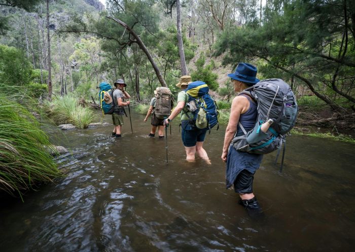
Many of NSW's best multi-day hikes lie hours inland. One such walk is the Green Gully Track in Oxley Wild Rivers National Park, part of the state's Northern Tablelands. This track isn't for the faint of heart, as it has multiple steep ascents and descents, and sometimes on unstable ground. What makes this undertaking a bit different from some of the other multi-day hikes in NSW is that it requires a booking of at least two hikers. While this might ruffle the feathers of free-spirited adventurers who like to live life day to day and hike to hike, it also ensures the park isn't overrun. And it means you don't have to worry about lugging too much gear with you. Leave the tents at home because you'll be staying in established huts that dot the trail. These refurbished heritage huts have beds, toilets, rainwater and cooking equipment.
Also, unlike some of the other great NSW multi-day hikes and walks, Green Gully Track is a loop. That means you'll have much less trouble getting back to your car, so driving is a great idea. You'll get directions on where to park and how to access the huts when you register.
*Green Gully Track is one of the NSW Great Walks.
Green Gully Track, Yarrowitch - Credit: DCCEEW
Did the Light to Light Walk pique your interest, but seems a bit out of reach? Fear not, as there's a suitable alternative for those with easier access to the northern part of the state. A quick 20km drive up the coast from Coffs Harbour sits Coffs Coast Regional Park, and within it the Solitary Islands Coastal Walk. This multi-day hike serves up bunches of NSW beachside beauty and features multiple points at which you can duck in and out if you want to cut the hike short. However, for all the completists out there, this journey will see you covering 60km over the course of three to four days depending on your fitness level and how many extracurricular activities you want to do. These extras include, but are not limited to: swims in the ocean, relaxation sessions on the sand and stops in the many lovely beachside towns you'll come across during your travels.
In addition to sandy fun, you'll explore rocky outcroppings and bushland for a well-rounded walk through a collection of Australia's fantastic natural features. The southern tip of the walk sits at Sawtell, while the northern end is in Red Rock. There is parking available at either end, though you might need to organise a shuttle service back to your vehicle if you're going to cover the full distance.

Park Beach and Coffs Creek Solitary Islands Coastal Walk, Coffs Harbour - Credit: Robert Cleary | DPE
Stretching across the New England National Park, the New England Wilderness Walk is a great example of the ups and downs that can come with the best kind of multi-day hike. By the time you finish this epic trek, you'll have descended more than 1,000 metres from the edge of New England Tableland to the headwaters of Bellinger River. The early part of the trip serves up tasty views from Snowy Ridge before you begin to drop. This section will likely take up most of your first day. The ensuing sections of this trail take you across creek beds (your time with the beautiful Sunday Creek is a figurative, but not literal, high point), which could expose you to rather wet conditions depending on recent rainfall. Extra socks and waterproof boots are a must for any multi-day expedition, but they are especially important to have on this trip. As with all Grade 5 tracks, much of this hike is rather rugged, giving you another reason to make sure your footwear game is on point.
There's no shortage of excellent, flat spots at which to set up camp along the way. Many of them will have abundant firewood around, so even if the temp starts to drop you should be able to stay warm. Things kick off at the trailhead located off Point Lookout Road at the Wrights Lookout parking area. Leave the car here and organise a shuttle service to bring you back when you're finished.

Bush walking at New England National Park, Country NSW
This is it, the gold standard of NSW multi-day hikes. Clocking in at a whopping 250km, the Great North Walk stretches from Sydney all the way up to Newcastle, passing through Ku-ring-gai Chase National Park, Brisbane Water National Park and Berowra Valley National Park along the way. As you can imagine with a journey as long as this one, there’s a huge variety of landscapes and scenery: urban jungle, dense bushland, suburban neighbourhood scenes and small country town charm. There's also wide-open walking along the coast, plus cafes, pretty architecture, and plenty of lovely people and fellow walkers to meet en route.
It all starts from a sandstone landmark at Macquarie Place Park in the heart of the Sydney CBD and takes you to downtown Newcastle just over two weeks later. Along the way you'll move through plenty of towns and national parks, most of which will have accommodation options ranging from motels and rental properties to campsites. As with many multi-day hikes, you're best to take public transport to your starting point. This is especially true with a journey this long. If you're starting in Sydney, take a train, bus or ferry into the heart of the city. When you wrap up in Newcastle, you can take the train back to Sydney.
Go with a guide
The Great North Walk guide helps hikers plan a self-guided adventure, providing maps, options for shorter journeys, planning resources, accommodation suggestions and stories of the track’s history.

Great North Walk, Watagans National Park - Credit: John Spencer/DPE
Stretching across the wild, rugged peaks of Kosciuszko National Park, this hike is one of the most famous walks in the state. As the entire walk is above the tree line (the altitude point where trees can no longer grow), you get uninterrupted views of the mountain tops and the valleys, ravines and rivers in between.
The best time of year is November to April, when the track is clearly visible and the wildflowers bloom but experienced hikers with snow-ready equipment can tackle it all year round. At 22km and an average time of 6-8 hours, it’s possible for fit hikers to do it in one day but unless they are staying in a nearby lodge, most hikers split the journey into two days, camping remotely at a sheltered spot (Mt Townsend plateau is popular). As appealing as it is to picnic on the highest peak in the country, it’s best to find a snack spot just beforehand. Also, know the weather is unpredictable on the mountain, so pack gear for all temperatures.
Go with a guide
Park Trek has been hiking to the top of Kosciuszko National Park for decades. They take you and a small group on a four-day, 46km journey starting and finishing in Thredbo (pick up and drop off in Canberra). A duo of guides lead the trek, pointing out local flora and fauna, regaling you with stories and preparing your meals at the end of the day.

Wagun picnic area on the Main Range track, Kosciuszko National Park - Credit: Murray Vanderveer/DCCEEW
Staring off in Settlement Point, to the north of Port Macquarie, and finishing in the quiet beach village of Crescent Head, this hike shows off the natural beauty of the North Coast. You’ll pass through Limeburners Creek National Park and Goolawah National Park, seeing a coastline decorated with banksia, blackbutts and rainforest naturescapes. As the hike is one of the lesser-known routes, you may not see many other travellers on the journey; keep your eyes sharp for local wildlife such as koalas, quolls, rose-crowned fruit doves and even the rare ground parrot. If you’re hiking between May to November, you’ll likely see one of Australia’s greatest natural sights: the migration of the humpback whale.
Hikers can set up around the halfway point at a series of campsites and cottages between the Big Hill picnic area and Racecourse Head. At the end of the walk, the seasonal (closed in winter) pizzeria, The Bush Kitchen, serves up woodfired meals to anyone who wants a break from their picnic options. Getting back from Crescent Head can be tricky. Public transport is a journey almost as long as the walk, so getting a private coach or booking ride shares are more efficient options.
Go with a guide
Positive Energy Adventures & Retreats stretches the journey into three days, prioritising relaxation and savouring the moment. Either join a small group or go solo; either way, let the sustainability-focused tour company handle your pack, accommodation and meals from a local caterer specialising in ethical and organic cooking. Group tours also come with morning wellness sessions and celebratory sundown drinks.

Goolawah National Park, Crescent Head - Credit: John Spencer/DCCEEW
VisitNSW.com is the official tourism site for Destination NSW.
© Copyright 2026 Destination NSW. All rights reserved


