


Newcastle may be the second most populous area in NSW, but the North Coast city’s heart is rooted in Mother Nature. Whether you’re wandering coastal headlands or exploring native forest, this pocket of NSW is home to a world-class collection of trails.
The Bathers Way Walk
In a nutshell: A stunning 6km path connecting a collection of the North Coast’s most scenic beaches.
The essentials:
- Parking? Yes, at the start and end of the walk near Merewether Baths and Nobbys Beach, and at other points along the route, including King Edward Park, Bar Beach and Dixon Park Beach.
- Distance: About 6km
- Difficulty: Easy/moderate
If the sun is shining and the temperature is creeping up, there are few better ways to spend the day than going on a beach crawl via The Bathers Way Walk in Newcastle. This legendary coastal stretch of paved pathway links Merewether Baths in the south to Nobbys Beach and Nobbys Lighthouse in the north. It’s a popular route, but thanks to the wideness of the trail, there’s plenty of room for walkers and runners of all speeds to navigate and still enjoy the experience.
There are excellent views to be had all year round – of the city and harbour from the ANZAC Bridge, with massive coal loaders and cruise ships navigating the port. But things can get pretty spectacular over the cooler months (May through November), when the Pacific becomes the ‘Humpback Highway’ – more than 30,000 whales cruise up and down the east coast during this migration period, often with dolphins in their wake.
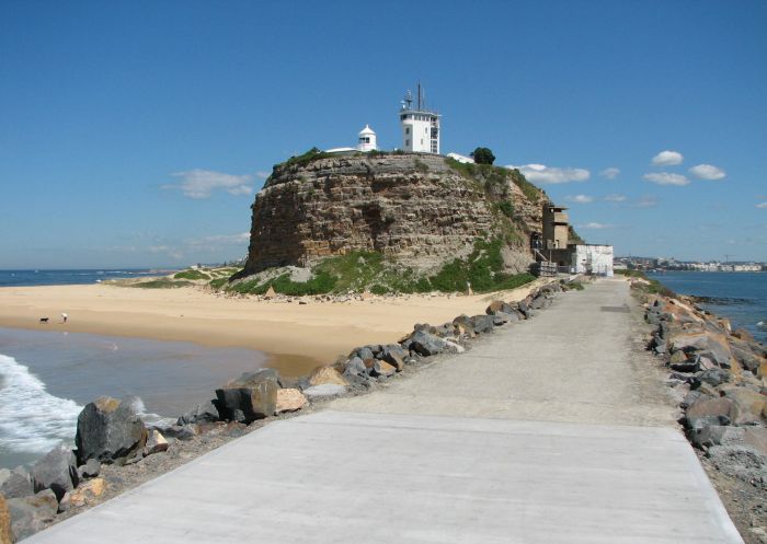
Nobbys Lighthouse - Credit: The City of Newcastle | Newcastle VIC
Blackbutt Reserve
In a nutshell: A collection of walking trails ranging from easy to difficult, located about 9km west of the Newcastle CBD.
The essentials:
- Parking? Yes, off Lookout Road, Carnley Avenue, and just off the corner of Freyberg Street and Mahogany Drive.
- Distance: 10.5km combined across the seven walking trails
- Difficulty: Easy/difficult
Blackbutt Reserve and its 180-plus hectares of native bushland is home to seven walking trails. None of these are too lengthy (the 2.6km-long Tall Trees Walk clocks in as the longest), which means you can easily tackle a handful of them in one visit. Or just one, if you have young explorers in tow, with little legs. Regardless of age, trekkers will be enthralled by the abundant wildlife.
There are three main entry points into the Blackbutt Reserve walking trail network, all of which have parking. On the eastern edge there's one off Lookout Road, which leads to a lush rainforest area full of native wildlife. Another is off Carnley Avenue, on the southern end of the reserve, and a third is at the junction of Freyberg Street and Mahogany Drive. These latter two feature picnic and barbecue areas, toilet facilities and playground areas. In addition to these great walks, there's a kiosk for ice blocks, drinks and other fun treats to reward yourself after a day of intrepid fun.
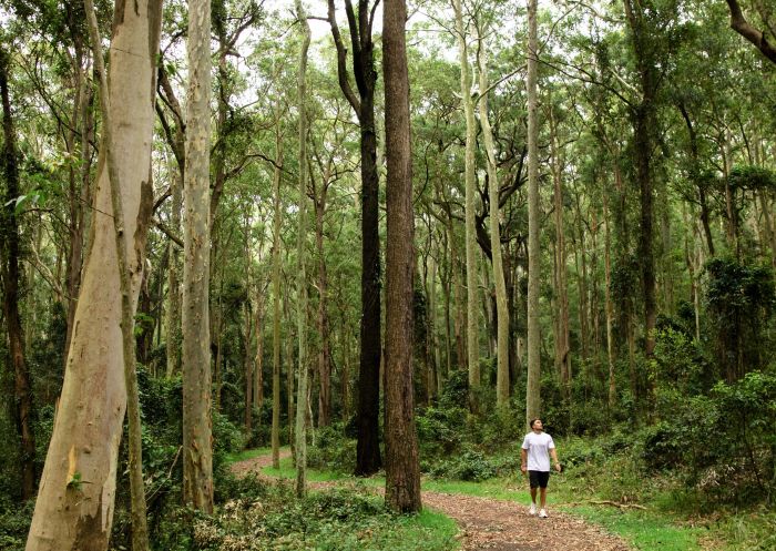
Blackbutt Reserve, Newcastle - Credit: Tyson Mayr
Fernleigh Track
In a nutshell: A long, popular, paved walking path suitable for walkers of all ages and ability levels.
The essentials:
- Parking? Yes, at multiple points along the track including at the start at Adamstown train station, Burwood Road, the junction of Station Street and Hudson Street, Cowlishaw Street, Railway Crescent and Railway Parade near the end of the walk in Belmont.
- Distance: 15km
- Difficulty: Easy
This famous paved (and mostly flat) trail may be 15km, but there are plenty of natural and manmade features en route that will make your journey feel like a breeze. Spanning an old railway corridor that connects Newcastle and Lake Macquarie, the track takes you past relics from a time gone by, as well as through the refurbished Fernleigh Tunnel.
Over the course of your hike you’ll explore sandy beaches, native bushland and bird-filled wetlands, including the Awabakal Nature Reserve, Glenrock State Conservation Area and Flaggy and Little Flaggy Creeks. There are also shops and cafes along the way, should you need to refuel.
There are a range of entry points with parking along the way, so you can cover smaller sections. But if you want to tackle the entire walk, start at Adamstown train station, a 7km drive west of the Newcastle CBD. Amble south until the end of track at Belmont in Lake Macquarie. Be aware that you will most likely be sharing this path with cyclists, as many use it to commute or as an avenue for exercise, so make sure to keep your head on a swivel while walking.

Fernleigh Track, Belmont - Credit: Lake Macquarie City Council
Yuelarbah Walking Track
In a nutshell: Glorious bushland hiking and walking trails sitting just outside of Newcastle.
The essentials:
- Parking? Yes, at Yuelarbah car park
- Distance: Just under 7km return
- Difficulty: Moderate
While Newcastle is home to some of the best beaches in New South Wales, its incredible inland attractions shouldn't be ignored. One shining example of the bushland beauty awaiting you is Glenrock State Conservation Area, home to some of the very best Newcastle hikes and walks. Near the top of this list is the excellent Yuelarbah Walking Track, which sits about 10km southwest of the Newcastle CBD.
This return hike is part of the enormous, 250km Great North Walk. On this humble section of the iconic trek you'll enjoy a wonderful collection of natural beauty, from creeks and rainforests to waterfalls and, at the end, a piece of the glorious Newcastle coastline from which you can hop in for a cooling dip. The Leichhardt Lookout and its view of the Glenrock Lagoon are a highlight in all senses of the word.
While not terribly taxing, this Grade 3 outdoor adventure is probably better suited for those who like their hikes to be a shade on the challenging side. Make sure you're rocking some boots or other solid footwear and a day pack with some water and snacks (and your swimmers!) so you can get the most out of your day on the trails.

Glenrock State Conservation Area - Credit: John Spencer | DCCEEW
Newcastle Memorial Walk
In a nutshell: A short but incredibly rewarding stretch that honours the city's heritage and thousands of brave ANZACs.
The essentials:
- Parking? Yes at the top of the hill near Strzelecki Lookout (limited) or at Bar Beach and King Edward Park car parks.
- Distance: About 450m
- Difficulty: Easy
Built in 2015 to honour the 100-year anniversary of the Gallipoli landings and Newcastle's history as a vital steel production centre, the Newcastle Memorial Walk is a gorgeous boardwalk that honours a momentous history, and offer views of the city and the Tasman Sea.
Start at the top at the Strzelecki Lookout and walk over the 160-metre clifftop bridge. You'll see steel silhouettes of soldiers on each side of you, with thousands of names soldiers from the Hunter region who fought in WWI. While short in distance, this walk is deep in meaning and worth your time, whether you visit it on its own or roll it into your journey on the Bathers Way Walk.
Similar in sentiment to the Memorial Walk is the Newcastle at War walk, a route that's been put together by the city of Newcastle to give walkers a peek into how battles at home and abroad shaped this proud city. Spanning about 4.5km of Newcastle East, it includes forts, museums, libraries and other locales full of primary documents and subject matter experts that can transport you back in time. Pick and choose from the 12 planned stops on the walk, or visit them all for an incredible, eye-opening experience.

Newcastle Memorial Walk, Newcastle
Warners Bay Foreshore
In a nutshell: Venture outside the city for a stroll around part of the massive Lake Macquarie.
The essentials:
- Parking? Yes, at Lions Park car park in Eleebana
- Distance: About 9km
- Difficulty: Easy
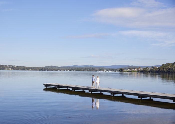
While hiking the entire perimeter of the 110-square-kilometre Lake Macquarie would take days, you can get a taste of one of the largest saltwater lakes in the Southern Hemisphere courtesy of this much more manageable 9km (one way) walk that connects Eleebana on the lake's northeast and Booragul on the lake's northwest.
While the glistening lake is lovely in its own right, there's plenty of other eye candy dotting the landscape as you make your way around in the form of amazing art from local creators, thanks to the Creative Lake Sculpture Trail initiative. As with many of these great Newcastle hikes and walks, there are plenty of opportunities to grab a coffee and a snack on the way, and there are several parks at which you can stop if the kids get tired of staying on the walkway.
Creative Lake Sculpture Trail, Warners Bay


