


There’s nothing that connects you to nature – and to your sense of adventure – quite like a bushwalk. From climbing Australia’s tallest mountain to chasing waterfalls in ancient rainforests, find your path on these hikes in NSW national parks.
Crystal Shower Falls Walking Track, Dorrigo National Park
- Distance: 4.4km return
- Suggested duration: 2 hours
- Difficulty: Grade 2
Just an hour’s drive inland of Coffs Harbour, Dorrigo National Park forms part of the Gondwana Rainforests of Australia World Heritage Area, a natural wonder literally millions of years in the making. While there are a number of fantastic walks to choose from to explore this lush rainforest, the Crystal Shower Falls Walking Track is particularly special: rewarding hikers with views from the rocky cavern behind the waterfall.
Starting from the Dorrigo Rainforest Centre, factor in an extra 20 minutes so you can check out the cantilevered Skywalk lookout before starting your hike. From here, it’s a 4.4km Grade 2 circuit to and from the falls underneath an ancient, towering canopy, with the call of lyrebirds, regent bowerbirds and wompoo fruit-doves as your constant backdrop. Loop back to the Rainforest Centre on the Wonga Walk to see the pretty Tristania Falls, and take a side trip to the elevated Walk with the Birds Boardwalk for some close-up birdwatching opportunities.

Family taking in the views at Crystal Shower Falls, Dorrigo National Park
Bald Rock Summit Walking Track, Bald Rock National Park
- Distance: 3.2km loop
- Suggested duration: 2 hours
- Difficulty: Grade 5
While Uluru may have been topping travel wish lists for decades, NSW has its own giant rock which is just as impressive. Just 35km northeast of Tenterfield, straddling the Queensland border, Bald Rock is the largest granite monolith in Australia. The behemoth clocks in at 750m long and 500m wide, and rises more than 200m above the surrounding eucalypt, wattle and blackbutt forest. You can climb to the summit in one of two ways: directly up the rockface, or via the more picturesque and leisurely Bungoona Walk.

Bald Rock Summit Walking Track in Bald Rock National Park, Tenterfield
Tomaree Head Summit Walk, Tomaree National Park
- Distance: 2.2km return
- Suggested duration: 1.5-2 hours
- Difficulty: Grade 5
For the ultimate bird’s-eye view of Port Stephens, lace up your walking shoes for this short but challenging hike to the spectacular summit of Tomaree Head. The Grade 5 incline is not for the faint of the heart – although it is only a 1km one-way trip, you are 161 metres above the Port Stephens entrance at the highest point.
The payoff is well worth it. Sweeping views of the surrounding coastline greet you at the top, from Zenith, Wreck and Box Beaches all the way to Cabbage Tree and Boondelbah Islands – nature reserves home to the world’s only nesting sites for the endangered Gould’s petrel. Pack your binoculars and search the horizon for whales (between the months of April and November) and pods of dolphins.

Tomaree Head Summit Walk, Port Stephens
Bouddi Coastal Walk, Bouddi National Park
- Distance: 8.5km one way
- Suggested duration: 4.5 hours
- Difficulty: Grade 3
If you are looking to escape the hustle and bustle of Sydney, the Central Coast is just a hop, skip and a jump away – and offers outdoors opportunities aplenty. Get a taste for the region’s natural beauty on the Bouddi Coastal Walk, known for its crowd-free beaches, easy-to-navigate boardwalks and glorious ocean views.
Stretching from Putty Beach to Macmasters Beach, highlights include the panoramas at Gerrin Point Lookout, the Instagrammable tessellated pavement near Bullimah Beach and the crystal-clear waters of Maitland Bay – where you should allow yourself enough time to enjoy a dip and check out the remains of the PS Maitland shipwreck.

Bullimah Beach located along the Bouddi Coastal Walk, Bouddi National Park
Hermitage Foreshore Track, Sydney Harbour National Park
- Distance: 1.8km one way
- Suggested duration: 1 hour
- Difficulty: Grade 3
Brimming with family-friendly beaches (there are five in total to choose from perfect for a swim, picnic or pit stop) and historic sites (the grand19th-century Strickland House can be found en route), as well as stunning views of the harbour, Harbour Bridge and city skyline, it’s little wonder the Hermitage Foreshore Track is considered one of Sydney’s great coastal walks.
Located within the Sydney Harbour National Park, begin the walk at Bayview Hill Road so that you can finish at the charming Nielsen Park. Here, you can relax with a coffee at the harbourside cafe, swim or kayak among the gently lapping waters of Shark Beach, or settle in underneath a shady fig tree for a picnic.

Friends enjoying a walk along Milk Beach on the Hermitage Foreshore Track, Vaucluse
Grand Canyon Track, Blue Mountains National Park
- Distance: 6.3km loop
- Suggested duration: 3-4 hours
- Difficulty: Grade 3
Dating back to 1907, the historic Grand Canyon Track takes you into the heart of the World Heritage-listed landscapes of the Blue Mountains National Park and has long been regarded as one of the top hikes in the region. An added bonus? The start of the track is just a 1.5-hour drive from Sydney, making it a very do-able day trip.
Hikers can enter the track from either Evans Lookout car park and go in a clockwise direction, or from Neats Glen car park and go in an anti-clockwise direction. The latter means you can end the journey with the arresting vistas of Evans Lookout – a nice reward after the tough climb back out of the canyon. Either way, expect a steep descent that gets greener and more beautiful with every metre you drop. Giant ferns and golden wattles line the pathway, which passes by a series of dramatic sandstone walls and overhangs, as well as cascading waterfalls and creeks.

Couple enjoying a scenic walk along the Grand Canyon Track, Blackheath
Pigeon House Mountain Didthul Walking Track, Morton National Park
- Distance: 5km return
- Suggested duration: 3 hours
- Difficulty: Grade 4
One of the best South Coast walks is to the top of the iconic Pigeon House Mountain. Just a 40-minute drive inland from the beachside town of Ulladulla, hikers pass through bush and heathland before reaching the real challenge: ascending a series of ladders criss-crossing multiple rockfaces to reach the summit. Catch your breath and then marvel at the magnificent 360-degree views of Morton National Park and the Shoalhaven region. On a clear day, you can see as far as Jervis Bay in the north and Bermagui to the south. Keep your eyes peeled for kangaroos and lyrebirds on the return journey.

Pigeon House Mountain Didthul Walking Track, Morton National Park
Breadknife and Grand High Tops Walk, Warrumbungle National Park
- Distance: 14.5km loop
- Suggested duration: 5-6 hours
- Difficulty: Grade 4
The National Heritage-listed Warrumbungle National Park is reason alone to visit this area of Country NSW. The jagged Warrumbungles (the name means 'Crooked Mountains' in the local Gamilaroi language) rise dramatically out of the surrounding plains, creating a rugged, volcanic landscape of eucalypt-dotted ridgelines that is a sight to behold. The crowning jewel is the 100m-high dyke known as The Breadknife, accessible on the striking 14.5km Breadknife and Grand High Tops Walk. When you hit 960 metres at Grand High Tops, one of the best views in the state unfurls before your eyes – a craggy patchwork of rock spires, needles and bluffs.

Kosciuszko Walk – Thredbo to Mount Kosciuszko, Kosciuszko National Park
- Distance: 13km return
- Suggested duration: 4-5 hours
- Difficulty: Grade 3
If you’re visiting Kosciuszko National Park in the summer months, scaling the summit of mainland Australia’s highest mountain is a must-do. Beginning at the top of the Kosciuszko Express Chairlift at Thredbo – a thrilling 15-minute joyride that sweeps up the mountain for 560 vertical metres, offering wonderful views of the national park and Thredbo Valley – the 13-kilometre Kosciuszko Walk is a great option for those wanting to tackle Mount Kosciuszko but are short on time, only taking around five hours to complete.
After the scenic chairlift, you’ll pass through the boulder-strewn plateaux of Ramshead Range and, in the springtime, rolling meadows of wildflowers, before crossing the Snowy River and ambling alongside the pretty Lake Cootapatamba, the highest glacial lake in the country. From here, it’s a gradual climb to the summit, which clocks in at 2,228 metres above sea level. Breathe in the fresh alpine air and prepare to be awed by the expansive 360-degree vistas of the Snowies.
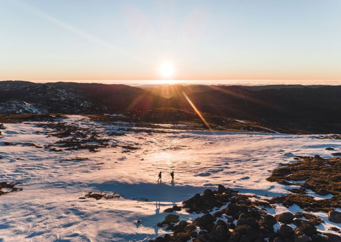
Backcountry, Kosciuszko National Park
Red Top Lookout and Boardwalk, Mungo National Park
- Distance: 100m circuit
- Suggested duration: 30 minutes
- Difficulty: Grade 2
Remote and starkly beautiful, the ancient Mars-like landscapes of Mungo National Park must be seen to be believed. Covering 27,850 hectares, the park's history is just as immense as its size: home to Mungo Man and Mungo Lady – the famous remains of people cremated here about 42,000 years ago – Aboriginal culture has existed here since time immemorial.
The wheelchair-accessible Red Top Lookout and Boardwalk is an unbeatable vantage point, offering a bird’s-eye view of the park’s deeply eroded ravines and lunette sand dunes. From Mungo Visitor Centre, it's an easy half-hour drive to the start of the track via the Mungo Self-Guided Drive Tour. Don’t forget your camera and, if time allows, come at sunset when the fading light transforms the scenery into a vibrant tapestry of every shade of orange you could imagine.

Scenic sand formations in the UNESCO World Heritage-listed Mungo National Park, Outback NSW
Please note: Due to ongoing works and weather conditions, tracks and sections of tracks may be closed for certain periods throughout the year. When planning your hike, always check the NPWS website for more information.


